Sample map showing trail sectors
 Sample of trail signs Sample of trail signs
|
 |
 |
 |
 |
 |
 |
| Bark
Lake (2.6 km) * |
 |
|
|
|
| Bear
Mtn. (0.7 km) |
|
|
 |
|
| Burnetts (4.2 km) |
|
|
|
|
| Burnetts Mtn. (0.7 km) |
|
|
|
|
| Crossover (0.5 km) |
|
|
|
|
| Eagles
(1.8 km) |
|
|
|
|
| East
Bluff (0.4 km) |
|
|
|
|
| Fish
Lake Mtn. (2.1 km) |
|
|
|
|
| Loon
(1.9 km) |
|
|
|
|
| Loon-Beaver (4.3 km) |
|
|
|
|
| Maurice's Dream (2.8 km) |
|
|
|
|
| Moose
(2.8 km) |
|
|
|
|
| Partridge (2.6 km) |
|
|
|
|
| Ramblers Way (5.1 km) ** |
|
|
|
|
| Raven
(2.3 km) |
|
|
|
|
| Ridge
(0.8 km) |
|
|
|
|
| Spectacle Lake (6.8 km) *** |
|
|
|
|
| Spectacle Ridge (2.4 km) |
|
|
|
|
| Wolf
(2.1 km) |
|
|
|
|
| Wolf
Lake Loop (1.3 km) |
|
|
|
|
* Use with caution in winter as an occasional
snowmobile may pass.
** Use only old road section for cross-country
skiing.
*** Use only section west of junction with Spectacle Lake Road in
winter. Occasional snowmobile may pass through this section. |
|
|

(PDF version of Bulletin)
Spring-Fall Trail Activity Map
Winter Trail Activity Map
Access Trailhead Signage
Maps

Virtual
Tour
Virtual Hike
Videos (YouTube channel)
Brochure & Map
Calendar
Weather
|

The 50-kilometre trail network is comprised of three interconnected sectors, namely– Bear Mountain,
– Spectacle Lake &
– Burnetts Mountain. The sectors are delineated on the downloadable and printable maps. 
Type of
activity use for each trail is based on requirement to minimize ecological
damage and to conform with land-use guidelines from Ontario Ministry of Natural
Resources & Forestry.
Hike |
Snowshoe |
Bicycle |
X-C ski |
The table at left identifies the authorized activity use for
each trail.
Download version of trail activity use table
(PNG).
Printable version of
trail activity use table (PDF).
Immediately below are maps with trail season-use symbols. 
Hiking and bicycling (off-road non-motorized) are permitted on designted trails as per Activity Use Chart at right.
Map with symbols indicating permitted activity on particular trails.Download version (high resolution) JPG image or PNG image
Printable version (PDF) 2-page letter size or tabloid)

Snowshoeing and cross-country skiing (backcountry style) are permitted on designted trails as per Activity Use Chart at right.
Map with symbols indicating permitted activity on particular trails.Download version (high resolution) JPG image or PNG image
Printable version (PDF) 2-page letter size or tabloid) Extensive
snowmobiling activity in Burnetts Mountain sector precludes use of these trails
for snowshoeing and cross-country skiing. Trails in the other sectors are
ungroomed — use is for back-country type of snowshoeing and cross-country
skiing.
Only advanced skiers should make use of these trails. The
back-country trails are not mechanically groomed, and the deeper snow found
there can make skiing conditions considerably difficult.
For your
safety, we recommend that you carry a small first aid kit, extra clothing, a
snack and trail map. Do not snowshoe or ski alone, ensure that someone knows
your itinerary and carry some means of communication. Cell phone service is now
available in the area.

The trail network was designed to
provide links between all the primary trails. This allows the user to plan a
couple of hours on the trail or make it an all-day outing, and to take just a
short jaunt or a more vigorous endeavour covering as many kilometres you care
to do.
All
trails have vantage points offering stupendous panoramic views in all seasons.
See photo gallery to get a taste of
what awaits you.

Names were assigned to the trails to reflect
geographic location, geologic feature or animals and birds observed along
route. Maurice's Dream honours the trail network's visionary and
Ramblers Way in homage to the
trail-builders. 
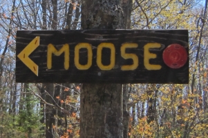
Trail names carved in wood are
mounted at all junctions, with arrows indicating direction of
trail.
Coloured discs mark the route of trail, with colour for each
trail matching that shown on the map.

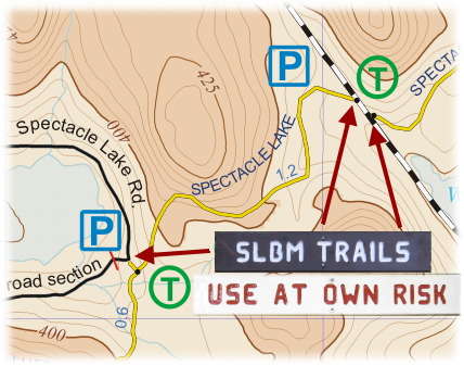
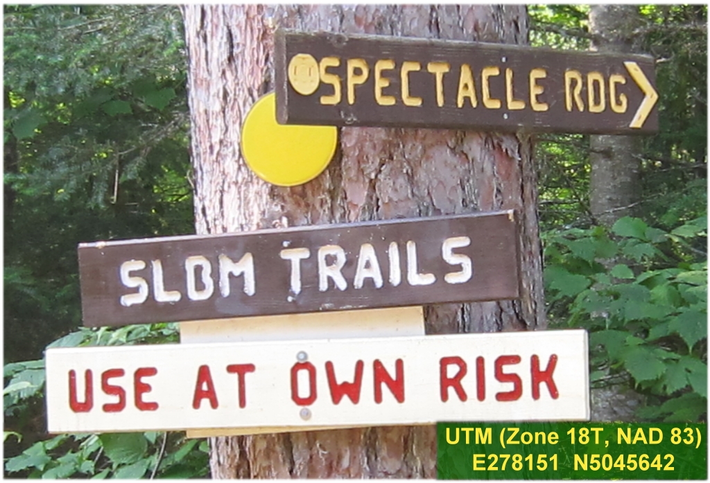
There are 5 access trailheads to the trail network. Sign combination "SLBM TRAILS" & "USE AT OWN RISK" marks the trailheads.
| Trail Network Access Points | | Access Trailhead
Location | GPS Coordinates * | | 1 | Hwy 60 - East (South side)3.1 km east from Spectacle Lake Road junction. | E278098
N5045687
(Photo) | | 2 | Hwy 60 - East (North side)3.2 km east from Spectacle Lake Road junction. | E278151
N5045642
(Photo) | | 3 | Hwy 60 - West (South Side)– 23471 Hwy 60
– 2.2 km west from Spectacle Lake Road junction. | E273993
N5045449
(Photo) | | 4 | Spectacle Lake Road - North (West side)– 0.8 km south from Hwy 60 junction. | E276430
N5045985
(Photo) | | 5 | Spectacle Lake Road - South– 2.3 km south from Hwy 60 junction – end of public road.
– Parking area. | E277423
N5045149
(Photo) | | * UTM (Zone 18T, NAD 83) |

A
variety of interactive and static maps are available to
be viewed, and trail maps can be downloaded into an electronic device or
printed.
Quick-link to season-use trail maps for download or printing.
> Non-winter
> Winter

Take a quick tour featuring highlights of sights and
activities on the trail network by watching this
slideshow.
For a more
comprehensive view of the trails through the four seasons go to the
photo gallery.

Take a
self-directed virtual hike on the trails to
satiate your curiosity of what awaits you.
The virtual hike can be a
useful tool to plan the route(s) of your next hike on the trails.

A wide selection of videos are posted on the SLBM Trails YouTube channel featuring actual hikes on the various trails through the four seasons.

The videos were recorded in 2.7K HD and, when viewed on large monitors, give the sensation (3D effect) that you are actually hiking, snowshoeing or cross-country skiing along the trails.
The videos can complement the above virtual hike utility as a planning tool to map out your next adventure on the SLBM Trails. 
A brochure with trail map (sample) is now available through, inter alia,
visitor information centres, selected tourist facility operators, outdoor
equipment and gear retailers, and recreation service providers in the Ottawa
and Madawaska valleys. See Links for list of locations
where brochure is currently available (indicated by **).

To help you plan a visit to enjoy the trails here are
calendars for (year link image PNG file & print link PDF file)

There are four distinct seasons in the Madawaska Highlands and Upper Madawaska Basin. For current weather conditions and forecasts, along with historic temperature and precipitation trends, check out the Weather page.

To plan
an extended visit to the Madawaska region check out the Links page for leads on other trails, meals,
accommodations, activities, etc.

Got a question or comment? Go to
- FAQs (Frequently Asked Questions) page, or
- Feedback page and use the convenient e-mail response
form.
|
|


